Course Maps
Including Aid/Refreshment Stations

Course Description
Elevation Profiles
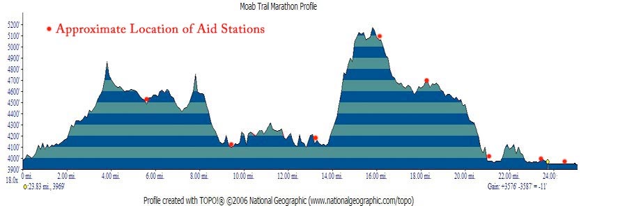
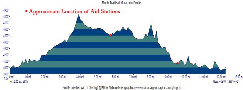
Location of Feed/Aid Stations (for Marathon and Half Marathon Course):
- Pritchett Canyon and Hunter Rim Road intersection (mile point 5.7, Full and Half)
- Hunter Canyon Rim Trailhead (at campground on Kane Creek Road at Gatherer Canyon, mile point 9.7, Full and Half)
- Amasa Back Parking lot: Water and Tailwind only (after Kane Creek Drainage, mile point 12.2, Half only)
- Cattleguard at turn to Scorched Earth Wall (mile point 14, Marathon only)
- “Taz’s Canyon” at bottom of slickrock scramble (mile point 17.5, Marathon only)
- Amasa Back Road and Jackson Trail junction (mile point 21.3, Marathon only)
- Kane Creek Crossing (just after creek crossing, mile point .75 of the 5k and mile 23.3 of the Marathon.)
- “Nelson’s Driveway” (after ‘Behind the Rocks’ Singletrack, mile 2.1 of the 5k and mile 25.2 of the marathon.)
Feed/Aid Stations will be equipped with water, Tailwind, Cliff Shots, snack bars, fruity, salty, and sweet snacks, oranges, bananas and Endurolytes. Also, basic first-aid supplies, an evacuation vehicle and communication ability.
Due to the remote location and rugged terrain of the course, vehicles are not able to access the route with food and water other than at these locations. Please carry your own water/food if you think you’ll need it!
Supporters of the Moab Trail Marathon

Who benefits from the Marathon